
Science done with ICOS data
ICOS data are used by scientists who seek to understand the Earth System and by various governmental bodies and international organisations that need science-based and relevant information on greenhouse gases to support their decision making and efforts to mitigate the consequences of climate change.
Our network consists of more than 500 scientists who participate in ICOS related work and operations. These scientists, both in current member countries and beyond, form the ICOS community. They design, build and operate ICOS stations, but even more importantly, process and use ICOS data while applying complex models to the data. They publish scientific papers, participate in workshops and conferences, and develop new measurement methods.
Catalyst of research on carbon and greenhouse gases
ICOS enables many types of studies related to natural carbon and greenhouse gas sinks and sources and the factors that cause changes in related processes. For example, the effect of climate change on ecosystems, such as plant growth or soil carbon stocks, the relationship between ocean carbon fluxes and ocean acidification, and how to separate natural and anthropogenic emissions.
Data provider to satellites and modelling
ICOS data lay the foundation for many other scientific fields. Satellites focused on carbon, greenhouse gases, and related parameters require trustworthy data, and therefore scientists using these satellite observations also indirectly make use of ICOS data. ICOS data are used by many different modelling approaches. Inverse models that estimate greenhouse gas fluxes from different surface areas use ICOS data directly. Dynamic Global Vegetation Models use ICOS studies to improve model parameterisation of biogeochemical processes.
ICOS is essential in bottom-up and top-down approaches
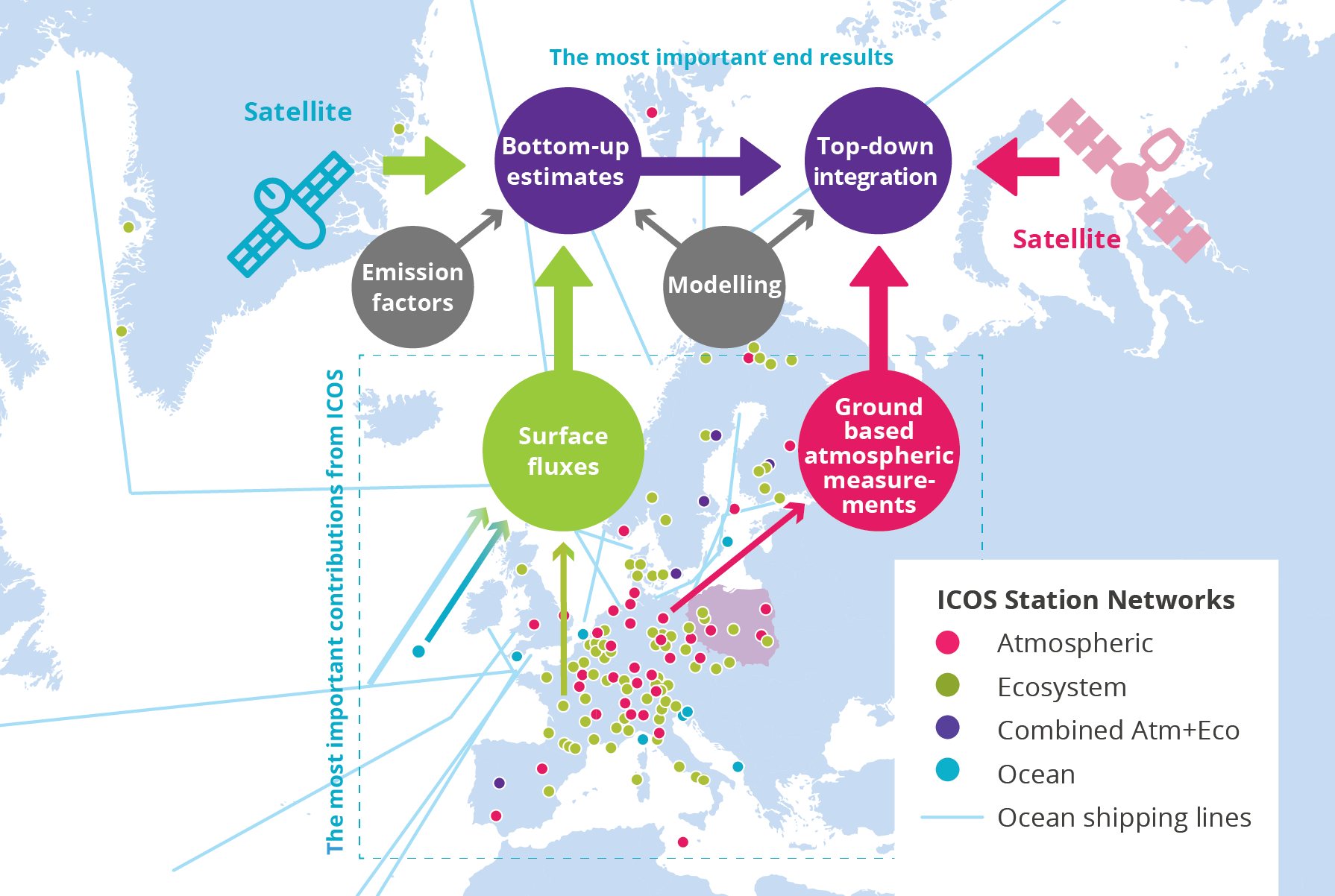
Scientists have developed and applied two complementary approaches to disentangle the combined effects of anthropogenic emissions, natural fluxes and atmospheric transport of greenhouse gases. The bottom-up perspective summarises information on all kinds of surface fluxes. The top-down perspective analyses the concentrations in the atmosphere measured at atmospheric stations or by satellites and use weather information to analyse transport. In combination, the two approaches build a powerful tool to provide knowledge on the complexity of natural and anthropogenic greenhouse gas fluxes that drives the atmospheric concentrations.
Data provider to global data networks
ICOS data are available through global data networks, such as the World Meteorological Organization's Global Atmosphere Watch (WMO GAW) and the Surface Ocean CO2 Atlas (SOCAT). The scientific users of these databases make use of ICOS data, and the Global Carbon Budget relies on these data sources as well as the above-mentioned modelling results.
Climate change policies
ICOS studies provide knowledge for the Intergovernmental Panel on Climate Change (IPCC). This knowledge, as well as the Global Carbon Budget, satellite observations and products provided by for example Copernicus, and modelling efforts, feed into national, regional and global policy frameworks related to climate change. Examples include national emission inventories and the United Nations Framework Convention on Climate Change (UNFCCC).