Terrestrial laser scanning at ICOS sites for time series of forest biomass estimations
Measurements of biomass content provide important data on the carbon storage potential of forests. A PhD project is developing continuous terrestrial laser scans at ICOS Ecosystem sites to test the potential of integrating 3D scans into long term monitoring.

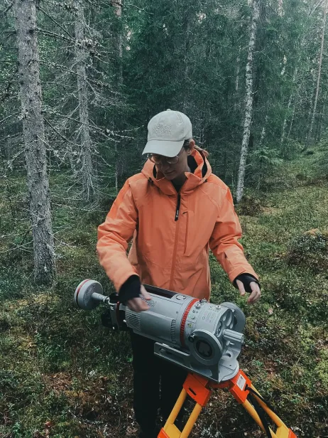
In spring 2025 Geike De Sloover, a PhD candidate at the University of Antwerp and Ghent University studying bioscience engineering and biology, conducted terrestrial laser scanning (TLS) of three ICOS Ecosystem stations in the Nordics – Hyltemossa and Svartberget in Sweden, and Hyytiälä in Finland.
“For my PhD research I make 3D versions of forest sites using a terrestrial laser scanner,” explains Geike. “At the University of Antwerp I am making scans at ICOS sites, and for my research at Ghent University, I scan tropical rainforests in Australia.”
When arriving at the ICOS stations, Geike and her colleagues Seppe Bresseleers and Kobe Happaerts (at Hyytiälä and Svartberget) placed the scanner on a tripod at various points to create an overall picture. “We took scans at 6 points within an inner circle, then at another 6 points from an outer circle,” says Geike. “That way they combine into one big, 3D version of the forest.”
The presence of permanent measurement equipment such as flux towers does not have a huge impact on the final scan and has been accounted for.
Why make 3D scans of forests? Geike explains that these scans create a ‘point cloud’ of the forest which can be used to measure many parameters.
“Once we have the 3D version of the forest we can measure all kinds of things like the diameter of trees, the height of trees, and the biomass that is stored in every individual tree. Because we have 3D models of each individual tree scanned, we can calculate the volume and, together with the density of the wood, get a highly accurate biomass estimation.”
Long term scans of ICOS sites
Geike’s PhD work builds on that of a previous PhD study by Miro Demol. In the end, Geike will have scanned all the same sites as the previous study, barring Norunda in Sweden (this is due to a clear-cut in autumn 2022 when an area of 300m around the main tower was turned into a clear-cut). Geike has already scanned the Nordic sites in spring 2025, with the remaining stations being Brasschaat (Belgium), Fontainebleau (France) and Hohes Holz (Germany) slated to be scanned in winter, after the leaves have fallen. The absence of leaves on the trees increases the accuracy of the scan. Since estimating volume and biomass focusses on the woody parts of trees, fewer leaves means saving time spent filtering out leaves and processing.
“By scanning the same forests using the same forest plots, we’re creating a temporal data collection of forest biomass over time,” explains Geike. “ICOS is a good fit for this sort of study because this would then fit in with the long timeseries of other measurements at ICOS sites.”
“From an ICOS perspective of long time series, laser scanning has a big benefit in that it is a non-destructive way of measuring biomass,” Geike notes. “When you want to measure biomass or tree volume, often you have to cut down the trees and actually weigh them. With laser scanning, the trees stay as they are and can continue to be observed.”

Terrestrial laser scanning for validating remote sensing observations
For Geike, laser scanning offers a lot of potential to the ICOS and wider community.
“The scans could be used in conjunction with the already-existing flux measurements to compare estimations of biomass at these sites,” Geike suggests.
There are also satellite projects which can benefit from terrestrial laser scanning, such as BIOMASS Earth Explorer, a recent initiative from the European Space Agency (ESA) which uses radar for biomass estimations. “Satellite observation missions have the benefit of being able to cover a huge area in a grid formation,” Geike outlines. These satellite observations would require validation from the ground to ensure their accuracy over time.”
Terrestrial laser scanning at ICOS sites could help provide the detailed “ground truth” needed to validate these satellite observations.
Upscaling to drone-based laser scanning (UAV-LS) is also a major element of Geike’s PhD research. These laser scanning measurements at ICOS sites are part of the NextGenCarbon project, with Geike’s terrestrial laser scanning being complemented by drone scanning, conducted by Benjamin Brede and others from GFZ Helmholtz Centre for Geosciences.
Could laser scanning become standard at ICOS Ecosystem sites?
Geike’s primary PhD topic investigates whether laser scanning can be integrated into ecological and environmental monitoring networks like ICOS.
For Geike – who is in the first year of her doctoral studies – there are still questions to answer. “Terrestrial laser scanning itself is quite labour intensive, and the data processing is tricky,” explains Geike. “It’s a very specific measurement, so it may not be so straightforward for any forest PI to immediately start working with these measurements.”
One of Geike’s goals is to investigate how this data could be integrated into databases like ICOS Carbon Portal. “This is something I talk about a lot with Bert Gielen (from the ICOS Ecosystem Thematic Centre and one of Geike’s PhD supervisors).”
“At the moment, the data is quite big and heavy, and hard to work with,” explains Geike. “The question at the moment is what data would we make available – do we give out the raw data, or do we provide more of an end product?”
In whichever format, the terrestrial laser scan data will be made available for download and use.
Of course, ICOS Ecosystem sites encompass more than just forests. While terrestrial scanning may not be viable at all sites, drone laser scanning – conducted top-down, rather than bottom-up, could be viable for different ecosystem types.
Geike suggests that drone laser scanning could be a suitable option for ecosystem sites such as croplands, due to some limitations of terrestrial scanning. “When looking at other sites like croplands, the vegetation is quite low and maybe not well suited to terrestrial scanning,” Geike points out.
Ultimately, Geike is optimistic that laser scanning could become a standard measurement at ICOS Ecosystem sites. “I’m optimistic because, for the sites I’ve visited so far, the station PIs and researchers have been very enthusiastic about it,” says Geike.
“Actually, at Hyltemossa they’re continuing to do terrestrial laser scanning even after I left. In addition to the continuous plots, we scanned some smaller plots. The researchers there then continued that work.”