Tracking methane emissions: Making the invisible visible
Countries are looking at how to make a 30% reduction of methane a reality by 2030, focusing on the oil and gas sector. For instance, in the US, the Methane Emissions Reduction Program introduces a charge on methane emitted by certain oil and gas companies. This charge will apply to facilities emitting over 25,000 metric tons of CO2 equivalent every year and will start at $900 per metric ton reported in 2024.
Meanwhile, the EU will soon pass a law to create reliable MRV for methane emissions and help reduce these within its borders and beyond. Alongside obliging the fossil fuel industry to roll out MRV, it will ban routine venting and flaring of gases, and mandates oil and gas companies to carry out regular surveys to detect and repair methane leaks in the EU.
Such efforts require data to implement and ensure their effectiveness.
“If you don't know where the emissions come from, then you cannot do anything about them. Also, when we are talking about having an effect internationally, then we have to extend our monitoring, reporting and verification outside our borders and this is only possible when we have reliable, comparable data,” says Jutta Paulus, a Green MEP from Germany, who helped negotiate the EU’s methane law.
She says that measuring methane emissions has gained traction in recent years, not just in the EU but also in the US. The charge for methane emissions will also require reliable data, she explains.
That is where monitoring, reporting and verification (MRV) comes in. Systems vary from satellites that can measure large emissions, to more localised techniques, like drones and ground-based measurements. Together, these help build a picture of the scale and location of methane emissions.
“We know that the methane problem exists. We know that emissions are very, very much higher than what they are currently reported as, but we don't know how much is actually emitted,” explains Flavia Sollazzo, Senior Director of the EU Energy Transition from the Environmental Defense Fund Europe, a US- and UK-based environmental non-profit.
Monitoring from space gives a big picture
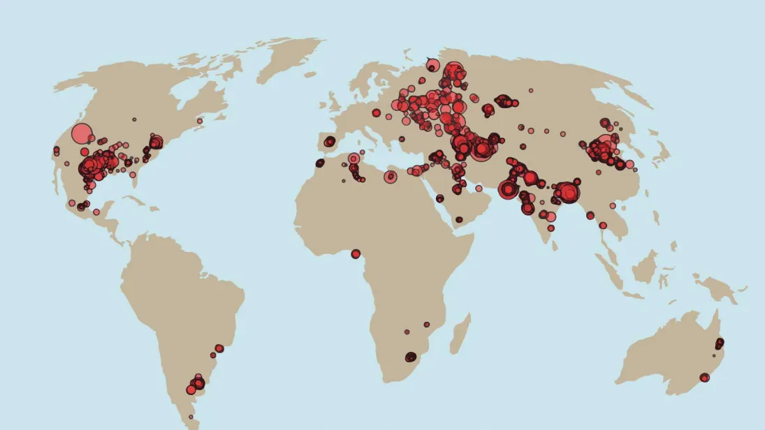
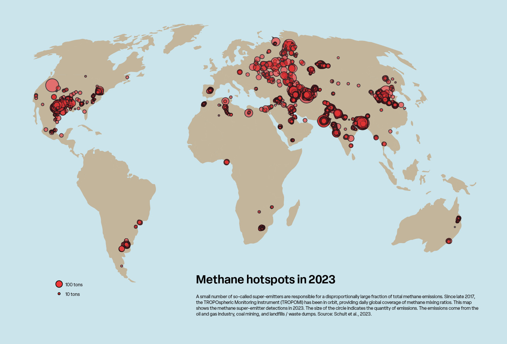
Methane emissions are easier for satellites to spot than carbon dioxide, due to the greenhouse gas being less present in the atmosphere. Satellites can build a picture of a wide area, find large sources, and access areas potentially inaccessible for ground-based techniques. There are several already in orbit, such as the Copernicus Sentinel-5 Precursor (S5P) mission, which monitors methane emissions in Europe and globally.
The satellite’s instrument detect the unique fingerprints of gases across different parts of the electromagnetic spectrum, delivering daily high-resolution global information on emissions. It has already revealed numerous individual incidents of unintended and deliberate methane leaks around the planet.
“We have detected several super-emitters also over Europe related to urban areas, e.g. Madrid and Bucharest as well as coal mining emissions in Poland and Ukraine," says Dr Ilse Aben, Senior Scientist at the SRON Netherlands Institute for Space Research and Co-Principal Investigator for the S5P TROPOMI detecting system.
“On a global scale, these methane super-emitters are only the tip of the iceberg in terms of overall total anthropogenic methane emissions. But they have also proved to be important in raising awareness for methane emissions – both at the political level and at the level of the polluters and other relevant stakeholders. Making visible what is invisible really works as an eye opener for many stakeholders,” she adds.
In 2026, another three satellites will be launched by the European Space Agency to help monitor carbon dioxide and methane emissions as part of the EU’s Copernicus programme.
The Copernicus Anthropogenic Carbon Dioxide Monitoring (CO2M) satellites will carry a near-infrared and shortwave-infrared spectrometer to measure atmospheric carbon dioxide and methane at high spatial resolution. The observations will be combined with ground-based measurements and modelling to understand human-made emissions compared to those from natural sources.
CO2M will be operated by the European operational satellite agency for monitoring weather, climate and the environment (EUMETSAT). What makes it pivotal, is that it will provide a unique and independent information source to assess the effectiveness of climate policy measures. Nations throughout the world will be able to assess and compare how they are meeting their targets with transparent data.
“EUMETSAT will operate the CO2M satellites and receive, process and disseminate their data, which will be crucial for monitoring carbon emission reduction efforts globally, in line with the Paris Agreement,” says Dr Phil Evans, EUMETSAT Director-General.
Meanwhile, the MethaneSAT mission, run by the Environmental Defense Fund, is already in orbit combining different types of monitoring: broad overviews and close-ups on problem areas. The satellite is revolutionary, both from a technological perspective but also because the data will show emissions over time and be freely available.
“It is the most advanced [methane-tracking satellite] now in operation because it has a 200 kilometres wide view and then it also has a high resolution to see small point sources as well,” says Sollazzo.
“It bridges the gap that there is at the moment. What it also does is that it basically continuously monitors emissions from up to 80% of the global oil and gas producing regions. This allows us to see quite quickly if there are changes,” she continues.
It is hoped that this type of technology will support laws like the EU’s upcoming methane regulation by providing a reference point to see if the data provided is accurate.
“Having the ability to see what the emissions are will allow us to set a baseline that then can be used in the EU for its current gas purchases, but then also across the board for buyers and sellers,” says Sollazzo.
Ground-based monitoring helps pin down leaks
While the exact range at which a satellite can measure methane emissions varies, they can only detect very big emissions.
“They do not provide all of the information needed to go out and fix leaks,” says Ioannis Binietoglou from the non-profit Clean Air Task Force. He wants to see a mix of complementary technologies, including ground-based measurements and emissions estimates, created using models or engineering calculations.
Ground-based methods include using flux chambers to capture and measure emission levels and lasers on mobile equipment, like drones and vehicles that can capture real-time data. These have to be converted to emission estimates.
“The approach of the mobile analysers is super successful,” says Dr Thomas Röckmann, Professor at Utrecht University.
“You have some idea from the modelling on the footprint area, but then the mobile analyser can go to the footprint area and try to find out where the point of emission is. Often you know that there is a farm or there is a wastewater treatment plant and so on, but then you go to all these individual installations and find out how they emit. So with these methods atmospheric research goes to a much more granular scale,” he adds.
Röckmann has used the technology to measure methane leaks in city gas networks and in previously unstudied oil and gas production areas in Romania. In both cases, the additional data helped raise awareness of the methane emissions and technology that can be used to track them.
However, there are still challenges in taking ground-based measurements, especially the accuracy of the emission estimates. This is because emission plumes move with the wind.
“If you transect the plume 10 times, you will get 10 very different results usually, and sometimes they can be an order of magnitude different, so that's really big because the plume dynamics change so quickly,” explained Röckmann. While there are some ways to reduce the meteorological variability, including taking measurements from further away, it is still a problem.
The most precise approach at the moment is the tracer release approach, where researchers release a gas not present in the area and measure it together with the unknown gas. This helps boost the accuracy of emission estimates, but can only be done when the emission point has been located and does not work when there are lots of emission points, such as in landfills.
Cooperation to use and improve MRV
While there is no global standard for MRV for methane emissions yet, the EU's methane law will help standardise some approaches.
Meanwhile, the US has a Greenhouse Gas Reporting Program that requires monitoring and reporting by regulated sources, including for methane emissions from petroleum and fossil gas facilities. This is verified through a combination of automated and manual checks that flag potential errors.
Another prominent system is run by the Oil and Gas Methane Partnership, a group of companies working with the United Nations to apply advanced monitoring and share best practices.
The group’s gold standard of MRV requires direct measurements of source-level methane emissions complemented by measurements of site-level methane emissions. This standard is used in over 38% of the global oil and gas production. It also forms the basis of the EU’s methane regulation.
While MEP Paulus believes the new EU law will be a big driver of methane emissions reductions around the world, more work is needed on the verification side.
“We do have a problem there because we simply don't have enough verifiers out there yet. I'm pretty confident that we still have some time [...] to bring them on board and to have sufficient people out there who can actually verify those emissions,” she explains.
Methane is a complicated greenhouse gas and there are still gaps in tracking emissions. Improved observation can help bridge these gaps, increase understanding of what is happening in the atmosphere and boost global efforts to reduce its impact on the climate, but more is still needed.