How ICOS helps Miro Demol to analyse how much carbon is stored in our forests
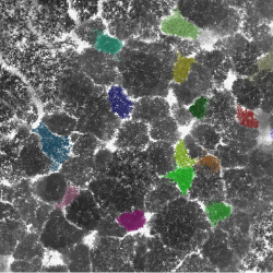
Miro Demol is a PhD student jointly supported by the University of Antwerp and the University of Ghent. His research focuses on measuring 3D forest structure and biomass through a modern technique called terrestrial laser scanning. Applications of these kinds of measurements include measuring air dust filtration by trees in urban environments, as well calculating the potential of forests as a carbon sink (Figure 1a and 1b). Beech trees in Germany and pine forests in Scandinavia are some of the many different ICOS sites that Miro has visited for his research. “We travel to the ICOS sites and scan the surroundings to get a three-dimensional point cloud of the forest. With this point cloud we can visualize structures and derive parameters of the forest”, Miro explains. Using a terrestrial laser to measure forests in ICOS sites scan gives Miro the advantage to participate from the knowledge of local technicians and researchers that supervise the measurement equipment and ecosystem sites.
Conventional measurement techniques require a lot of trees to be cut for research purposes
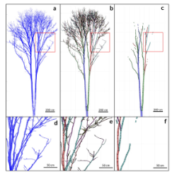
“In earlier times, estimating biomass of forests meant to harvest a lot of trees and weigh them”, Miro explains. Nowadays, techniques like the terrestrial laser scanning opened up the possibility to harvest trees virtually which cannot be cut down. In this way, researchers are now able to analyse the biomass of veteran or city trees without destroying nature or heritage sites. When looking at Miro’s 3D tree data for the first time, tiny points transforming into trees in black, white or various colours, can almost seem like you are observing pieces of art rather than scientific research material. “I know, the data looks very nice, but I can tell you that the analysis is quite tricky”, Miro clarifies. To calculate the volume of the tree, Miro zooms into its structure and fits cylinders into the tree’s different branches. “If you take a closer look at the point cloud you can see millions of tiny points. However, we want to learn about the volume, so we convert them into a cylinder model to make the calculations easier (Figure 2). Collecting the data with the laser scanner is really fast process, it is the analysis in the office that takes up most of my time.”, Miro says. “That’s why I like to repair my bike and work on something with my hands during my free time. It is a good balance to the time I spend at home and in front of my screen.”
ICOS sites are a great testing field for new technologies like terrestrial laser scanning
Throughout his PhD, Miro Demol has largely benefitted from ICOS’ network of unique and diverse ecosystem sites. He highlights: “All of the stations are managed by scientists, researchers and technicians with local knowledge which makes it easy to take measurements and access these places”. In terms of new technologies, ICOS sites also provide an ideal test field for new scientific approaches. The research infrastructure is, by its design, a long-term and a very detailed monitoring system providing high-quality measurement technologies but also room to try out innovative measurement methods like the terrestrial laser scanning. “ICOS is a great platform that that many people can benefit from”, Miro explains. “Without the research network, we would miss out on valuable knowledge of ecosystem sites across Europe, as well as the great possibilities that they have to offer for researchers and the scientific community.”